PART 1: LUMCLOON OF THE FLATTERYS
Content
- WHERE IS LUMCLOON
- LOMCLUNA NA FLATIRE
- BATTLES IN LOMCLUNA: 1285 & 1444
- PARDONS FOR THE FLATTERYS 1602
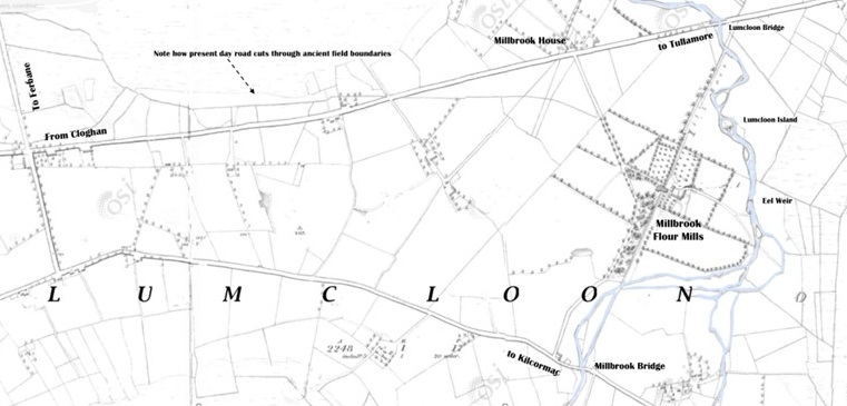
This map of Lumcloon townland based on the 1838 six-inch Ordnance Survey map shows the roads from Cloghan to Tullamore and Ferbane to Kilcormac. This map also depicts Millbrook Flour Mills which was part of the Birr Castle estate. Dennis Cassin who was miller here was a leading member of the United Irishmen along with Daniel Flattery of Cloghan. Both were in Dublin at the time of Robert Emmet’s rebellion in 1803 and were imprisoned in for a period.
Millbrook House is also shown which was the home of Canon Joseph Guinan (1863-1932) author of The Soggarth Aroon, The Island Parish, and other works.
1. WHERE IS LUMCLOON?
However there is another Lumcloon, Lomcluna na Flaitire, which is located much closer to Banagher and which has a rich and colourful history.
MANUSCRIPT NAMING TWO LUMCLOONS
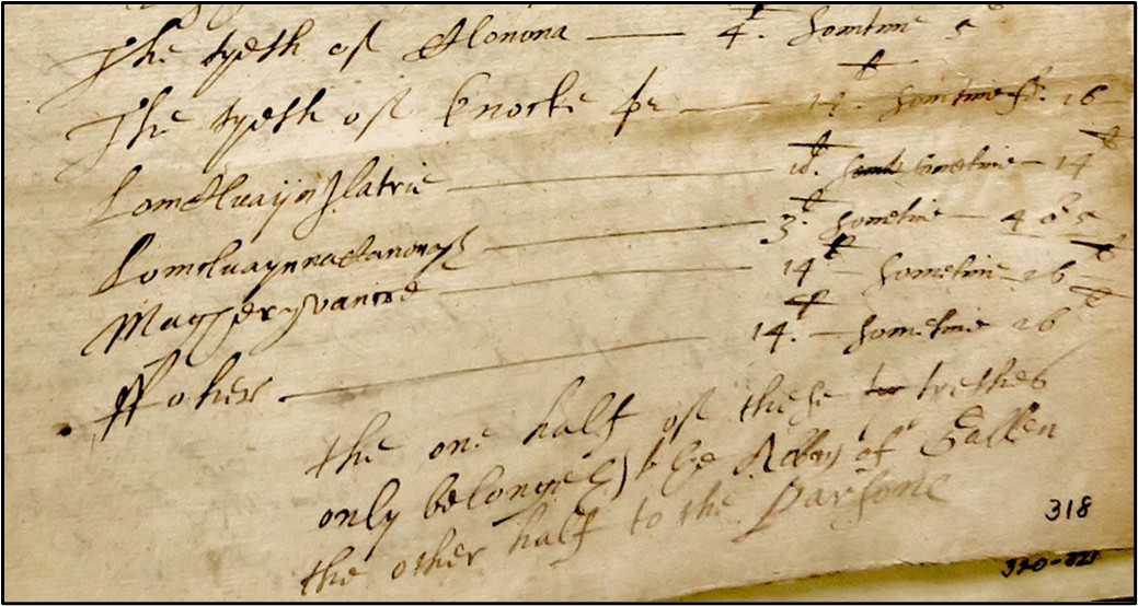
Below is an extract from the manuscripts of Mathew De Rensi (1577-34). It gives a rare insight into the actual and potential tithes due from individual townlands to the Abbey of Gallen four hundred years ago. The image clearly shows Lomcluaynaflatrie (Lomcluna na Flaitíre) and Lomcluaynnachanonogh (Lumcloon of the Canons) as two separate places which are valued differently and were therefore distinct and individual. Other local places such as Clonony, Knock, (Coraknock), Magheryvanne (Maherabane near Cloghan) and Ffoher (Wheery) are also discernible. A transcription of this image is given in the table below.
| The tithe of Clonona | £4 sometimes £5 |
|
The tithe of Knock
|
£14 sometimes £16
|
|
Lomcluaynflatrie
|
£10 sometimes £14
|
|
Lomcluayn na chanonogh
|
£3 sometimes £4 or £5
|
|
Magheryvanne
|
£14 sometimes £16
|
|
Fuhier
|
£14 sometimes £16
|
One half of the tithes only belonging to the Abbey of Gallen the other half to the Parson.
LUMCLUAYNNAGANANOGH (LUMCLOON OF THE CANONS)
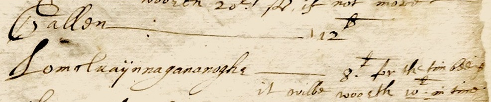
This second image from the same manuscript shows Lomcluaynnagananogh again with an increased valuation of £8 which could in time be worth £10. This undoubtedly refers to the Augustinian Canons Regular who had an abbey at Gallen from the twelfth to the seventeenth century. The exact significance of the placename Lomcluaynnagananogh as it appears twice in this document and also in the Down Survey is not fully understood.
This manuscript is a very rare ecclesiastical document in that it lists many local townlands in their parochial context giving their approximate value with regard to church dues before and after the 1620s and their potential value afterwards.
2. LOMCLUNA NA FLAITIRE
When listing the historic clans of County Offaly, the O’Connors, the O’Molloys, the O’Carrolls, the MacCoghlans, the O’Dempseys and the Foxes are rarely omitted. The O’Dunnes and O’Maddens from neighbouring counties may well be mentioned but reference is rarely made to the Flatterys. However some genealogical sources for the eight century indicate that the MacCoghlans derive their name and descent from Coghlan, son of Flatíle (Flattery), of the race of Cormac Cas. References in the annals in the eleventh and twelfth centuries describe some Flatterys as Lords and Princes of Delvin Eathra, which was to become the tuath or territory of the MacCoghlans.

LOMCLUNA NA FLAITIRE IN THE ANNALS
| 8th Century | Genealogists indicate that the Mac Coghlans of Delvin Mac Coghlan derive their name and descent from Coghlan son of Flaitíle of the race of Cormac Cas who can be traced to the eighth century. |
| 1053 | The Annals of the Four Masters: ‘Cochlán, king of Delvin Eathra, was treacherously killed by his own people’. |
| 1089 | AFM: Gillacainaigh Ua Flaithfhíleadh (Flattery), Lord of Dealbhna Beathra was slain by his brother Aedh, son of Cochlán Ua Flaithfhíleadh (Flattery). |
| 1135 | Annals of Clonmacnoise: Hugh MacCoghlan O Flatíle, prince of Delvin Beathra died |
| 1285 | The Annals of Clonmacnoise tell of a major battle in Lomcluna between Anglo-Norman forces and the Irish. |
| 1444 | The Annals of Ireland: Lomcluna I Flatíle is mentioned in 1444 as the site of a battle between factions of the MacCoghlan clan. |
| 1548 | AFM: ‘Cormac MacCoghlan and the Hy-many on the 9th May made an incursion into Delvin; and they burned and plundered Lomchluain-I-Flaithíle …..‘ |
| Footnote | In a footnote for this entry the great scholar, John O’Donovan incorrectly equated this area with the townland of Lumpcloon (sic), near the village of Cloghan. His additional observation ‘that the Flaitílys or Flatterys, as they are now called, are a branch of the Delvin Eathra, said to be senior to the MacCoghlans’, is of particular significance. |